A Border on Paper and a Border in Daily Life
A border on paper and a border in daily life do different work. Follow one invented town to see how a mapped line shapes movement, identity, and services.
A border on paper and a border in daily life can divide the same town in different ways. On a map, the boundary is a line; for people nearby, it may determine which road they take, which office handles a request, or how they describe where they belong. Those functions overlap, but none can stand in for the others.
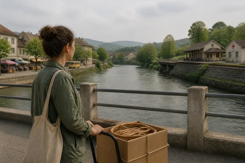
Consider the invented town of Bellwater, built around a river that forms part of the boundary between two neighboring countries. The market, school, and bus stop sit on one side; a clinic and a small rail station lie on the other. The situation is hypothetical, but its details help show why a political line does not explain every experience associated with it.
Bellwater’s mapped line settles one question
A map’s border answers a specific question: where does one state’s territorial jurisdiction end and another’s begin? In Bellwater, the boundary follows the river’s main channel, as defined by the countries’ agreed records. That line lets officials identify which side contains a parcel, a road segment, or a public building.
The map does not, by itself, say how easily a resident can cross, whether a particular crossing is open, or what documents a traveler needs. It also cannot tell a person’s language, family history, citizenship, or sense of home. Those questions belong to other systems and experiences, even when they are affected by the same boundary.
Imagine Mara, a fictional Bellwater resident whose apartment and workplace are both on the western bank. Her sister lives across the river. A map can show that the two homes fall under different national jurisdictions; it cannot show whether Mara can reach her sister directly or must travel to a designated crossing.
Keep the map’s role narrow: it locates jurisdiction, not the whole border experience.
The river shapes movement without replacing the boundary
For Mara, the river is an obstacle, a route, and a landmark. A bridge connects the banks, but it is also the town’s official crossing point. A second bridge used by local farm traffic ends at a closed gate. Both bridges matter to daily movement, yet neither changes where the international boundary lies.
Movement depends on practical arrangements built around the line. These can include crossing hours, transport links, inspection procedures, and rules for people or goods entering the other country. A border may be physically close while the permitted route is indirect. Conversely, an approved crossing can make a nearby place accessible without making it part of the same jurisdiction.
On a rainy morning, Mara plans to bring a box of handmade chairs to her sister’s workshop. The straight route crosses the river at the farm bridge, but the gate is closed to ordinary passenger traffic. She takes a bus to the official bridge instead, where the applicable rules determine whether the chairs may pass and whether she needs to declare them. The observable result is a longer journey and a separate administrative decision about the goods.
That small detour illustrates a useful distinction: geographic distance and permitted movement are not the same thing. A river, mountain pass, road network, or crossing regime can shape a trip without redrawing the political line.
Identity can cross a boundary in more than one direction
Bellwater’s residents do not all use the border as a measure of belonging. Some identify most strongly with their country of citizenship. Others speak a language heard on both banks, have relatives across the river, or feel attached to the town as a whole. A person may hold one legal nationality while maintaining close cultural and family ties elsewhere.
These connections do not make the boundary unreal, and the boundary does not erase them. A national identity, citizenship status, ethnic or linguistic identity, and sense of local belonging are distinct ideas. They may reinforce one another, conflict, or matter differently in different settings.
Mara’s family, in this invented scenario, has lived on both sides for generations. She calls herself a Bellwater local and also identifies with the country where she was born. At a school meeting, the question of which national curriculum applies is practical. At a family meal, the same line may be less important than shared memories and kinship. Neither setting makes one description the only true one.
For a reader, the practical habit is to ask what kind of identity is being discussed. A passport, a census category, a language spoken at home, and a person’s own account can describe different aspects rather than competing answers.
Administration assigns responsibilities to places and people
In Bellwater, the boundary determines which government is responsible for services within each jurisdiction. The town’s western bank has one municipal office; the eastern bank has another. The dividing line can affect where residents register a vehicle, apply for a permit, attend a public school, or report a local concern.
Administrative borders do not always match the routes people use or the communities they recognize. A clinic across the river may be the nearest medical facility, but its operating rules and eligibility requirements belong to the jurisdiction where it stands. A child might live close to a school on the opposite bank yet be assigned to a school in their own district. The mapped boundary identifies the relevant authority; separate policies determine how that authority handles a service.
Say Mara’s sister discovers that a delivery address is recorded under the wrong municipal office. In this hypothetical situation, she checks the address against the town’s official boundary map, then contacts the office responsible for that parcel. The expected observable result is a corrected routing for the request, not a change to the international boundary or her family’s connection across it.
When a service question arises, identify the place and the responsible office before assuming that the nearest facility has authority over it.
A border on paper and a border in daily life answer different questions
Some features of a border are visible: a river, a fence, a sign, a bridge, or a checkpoint. Others are less visible, such as jurisdiction over a parcel, eligibility for a service, or the paperwork needed to cross. The visible feature may mark or channel movement, but it does not necessarily explain the legal arrangement behind it.
Bellwater’s river is especially easy to misread. A visitor might assume the water itself is the border everywhere. In this invented case, however, the agreed boundary follows a defined channel, and the exact line is established through the countries’ official records. A river can shift, split into channels, or meet engineered banks; the legal treatment depends on the applicable agreement and records, not on a casual glance at the water.
Another common confusion is treating a border as a wall. The town has an international boundary, yet residents may cross at an authorized point under the rules in force. The presence of a crossing does not remove the boundary; it provides a regulated way to pass it. Likewise, a barrier may restrict a route without changing which state has jurisdiction over the land.
When a question turns on a boundary’s legal position or the rules for crossing it, consult the relevant official map, agency, or local authority; arrangements depend on the applicable documents and local rules.
What should a reader ask about a border?
Does a border always follow a visible feature?
No. A boundary may follow a river, ridge, surveyed line, or other agreed description, and parts may not be obvious on the ground. Official records are more useful than guessing from a fence, road, or watercourse.
Does living beside a border mean crossing is easy?
Not necessarily. A nearby crossing may have limited access or procedures, while another permitted route may be farther away. Distance alone does not tell you what movement is allowed.
Does citizenship determine a person’s whole identity?
No. Citizenship describes a legal relationship with a state, while language, ancestry, local ties, and personal identity describe other dimensions. They can overlap without being interchangeable.
Who handles a service request near a border?
Usually, the authority responsible for the location or service determines the process. Check the address and the agency’s stated jurisdiction rather than assuming that the closest office is the right one.
Use the right lens for the question at hand
Bellwater’s fictional journey began with a mapped river line and ended with several different practical answers. The map located jurisdiction. The bridge and its rules shaped a trip. Family ties influenced how residents described belonging. Local government assigned responsibility for an address or service. Each answer was connected to the border, but none replaced the others.
That distinction is useful whenever a border enters a news story, a travel plan, or a local dispute. Ask whether the issue concerns territorial jurisdiction, movement, identity, or administration. Then look for evidence suited to that question: an official map for location, the responsible agency for a service, current crossing information for a trip, and people’s own accounts for how they understand belonging.
A border on paper and a border in daily life are easiest to understand when neither is asked to do the other’s job. Start with the specific question, and the line becomes clearer without being mistaken for the whole story.